GPS & GIS in Agriculture
 Introduction
Geographic information systems (GIS) are in use in
several APHIS locations, including Cheyenne, WY, Los Angeles, CA, Bozeman, MT, Imperial,
CA and Phoenix, AZ. A GIS is useful to display and analyze information that has a
geographic component. A GIS usually consists of a database of geographic and related data,
coupled with the ability to display the data on maps, and manage and query the data. A GIS
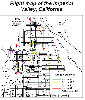
illustrates data attributes that are not otherwise apparent. For example, in Phoenix, we
use a GIS to display the location of cotton fields within a valley, the flight path of the
sterile insect release plane over those fields and the relative number of insects detected
in each field.
Global Positioning Systems (GPS) were developed
to provide for navigation in three dimensions. They are used by aircraft, ships, ground
vehicles and hand carried by individuals. A GPS may used alone to provide
"ballpark" positioning and navigational data. The coordinates provided by
standalone units are accurate only to 0 to 100 meters but are accurate enough to put a
plane within sight of the airport, for example, and as such are invaluable. The new GPS
units have increased receiver capabilities that track up to eight satellites (versus four
in the older receivers). This provides more accurate readings. Precise positioning is
provided by using a GPS unit in conjunction with a ground station at a known reference
location. The GPS compares its relative position with the ground station and is then able
to make corrections to its readings. This is called differential correction and is
accurate to 0 to 5 meters. Differential correction is valuable to us for collecting data
to describe points, lines and areas. Accurate descriptions of agricultural fields allow us
to calculate acreage, overlay the fields onto road maps, etc.
Another valuable new feature of GPS units is
internal recording of the latitude / longitude coordinates coupled with the ability to
download directly to a computer. This eliminates manual data recording and entry thus
saving time and reducing errors.
Requirements
An understanding of the implementation process.
Knowledge of GIS, GPS and database technologies. An appropriate level of expertise about
the hardware, software and the way in which the system will be used. Willing participants
at all levels, from field to administration. An adequate budget and sufficient allocation
of time (Somers 1996).
Basic Steps to Implementation
Planning - Clarify overall goals for the
project, describe resources (time, money, labor, data), establish a schedule or timetable.
Analysis - Analyze the resources you have (data, knowledge, skills, equipment) then
examine your needs, for example, you may need answers to questions that have geographic
components in order to make an optimal decision and take action to solve a problem. Design
- Determine what type of GIS will suit your particular situation. Design choices depend on
needs and resources. Acquisition, development and training - After selecting appropriate
equipment and software, these components must be put together into a working unit. Then
the GIS work begins. This work includes data acquisition, application development and user
training. Operation, maintenance and upgrade - decisions include who will use the GIS and
keep the data current. Routine maintenance is required as with any other system.
 The
Value of Having Good Maps
The
Value of Having Good Maps
We need to track various parameters (insect counts, plowdown, etc) for the agricultural
fields for which we are responsible. For that reason, the Arizona Cotton Research and
Protection Council, State of Arizona hand drew, in MapInfo, the boundaries of each field.
They began this project in the late 1980’s (as part of the Boll Weevil Eradication
Project). As references, they used the streets and physical boundaries already available
in MapInfo as well as field maps hand drawn by their field personnel. They provided us
with a copy of these maps and the maps were very valuable.
 However, we realized we required far more
precision in the maps in order to make management and regulatory decisions. We examined
the options available at the time. Keep in mind that the technology is dynamic and
standards change rapidly. We are fortunate in that the current technology is very
powerful, accurate and much more affordable than it was years ago. We compared current GPS
technology to aerial photos and compared ArcInfo to MapInfo.
However, we realized we required far more
precision in the maps in order to make management and regulatory decisions. We examined
the options available at the time. Keep in mind that the technology is dynamic and
standards change rapidly. We are fortunate in that the current technology is very
powerful, accurate and much more affordable than it was years ago. We compared current GPS
technology to aerial photos and compared ArcInfo to MapInfo.
We subsequently purchased GPS units, trained our personnel and have been collecting GPS
data. We continue to examine and consider other compatible technologies in a constant
effort to get the best data for the time and money spent.
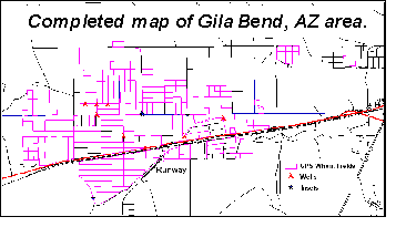
Our Current GPS Equipment and Its Use
We are now using hand held, differentially correctable GPS units made by Corvallis
Microtechnology in Corvallis, Oregon. These units, pictured above, have a full keypad for
descriptive data entry. They are programmed to record the specific types of points, lines
and areas in which we are interested. Programming is done on a regular computer and
downloaded to each GPS unit.
The feature file for our units is:
| Feature |
Attribute |
Value |
| Field |
Field # |
| -- |
Irrigation |
Choose One: Flood, Drip, Sprinkler |
| -- |
Row Direction |
Choose one:- N-S, E-W, Circular, Contour |
| -- |
Head Water |
Choose One: N, S, E, W |
| -- |
Crop |
Choose One: Alfalfa, Bermuda, Citrus, Cotton, Corn, Fallow, Melon, Orchard, Palm,
Safflower, Sorghum, Vegetable, Vineyard |
| Power Lines |
Location |
Fill in location, for example, “NS” indicating power lines on the North and
South sides of the Field. |
|
| Inset |
Type |
Choose One - House, Barn, Equipment Storage, Tree, Sump, Silo, Sub-Station, Business |
| Well |
Size |
6”, 8”, 10”, 12” |
| Section Corner, for example, Section 02 |
Location |
Choose One: NE, SE, NW, SW |
| BDO |
Offset # |
Use this offset to keep from entering private property and avoid bad dogs |
| Canal |
Section # |
This Feature is used only to define a canal that bisects a field. |
| Road |
Road type |
Choose one: Dirt, Paved |
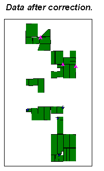
The person operating the GPS unit collects latitude/longitude data at each feature
site, as the situation requires. The unit stores the raw data for the entries day’s
work.
The data is downloaded to a desktop or laptop computer at the end of the day or work
period.
Meanwhile, the base station is continuously collecting lat/long data. The base station
collects lat/long data once per minute and compares the reading to its own, known
(surveyed to within millimeters) position. It then builds a “correction” file.
When the field data comes in, it is differentially corrected by calculating the
differences between what the base station recorded, at say 8:01 a. m., to what the base
station knows to its exact position. The base station’s reading at 8:01 a. m. may be
1 meter north of what the base station knows to be true so the field data that was
collected at 8:01 am is corrected by that amount, in the proper direction. The result is a
“differentially corrected” file that is highly accurate.
The corrected data is then imported into a GIS and appended to a larger map of the
region. We use the GIS MapInfo to query the database for to create thematic maps,
customize, display and print maps. Maps can be exported to other programs, such as this
presentation software. Maps are used to support regulatory, administrative and scientific
decision making, and are also used operationally for planning and job assignment.
CMTINC.COM
413 SW Jefferson Ave.
Corvallis, OR 97333 USA |
Tel: (541)752-5456 |
Fax: (541)752-4117 |
|
|
|
|
sales@cmtinc.com |
|
© Corvallis Microtechnology, Inc. 2000 All Rights Reserved
|