![]()
Superior DGPS Performance Under the Canopy
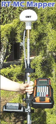
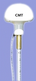
 Introducing
the newest addition to the CMT GPS products line. The RT-GPS is
an integrated GPS and Beacon Receiver Antenna. Every portion of
the GPS andBeacon Receiver is encapsulated in the RT-GPS antenna.
This unique system eliminates the need for any bulky backpacks or waist
packs.
Introducing
the newest addition to the CMT GPS products line. The RT-GPS is
an integrated GPS and Beacon Receiver Antenna. Every portion of
the GPS andBeacon Receiver is encapsulated in the RT-GPS antenna.
This unique system eliminates the need for any bulky backpacks or waist
packs.
Integrated in the GPS Antenna
Integrated in the GPS Antenna
Yes, MC5-Mapper
No
We recommend purchasing
a Pen-based or standard laptop computer
Yes, CMT Field 3.7 Included
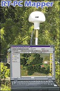
Yes,
CMT PC-Mapper 5.5
Windows-based
GIS/GPS with Integrated GPS/GIS
Field software
Yes
1
MB standard
2, 4 ,8
MB optional
Lines, and Areas:
Yes
Microsoft Windows® based
with Integrated GPS/GIS
Field software
 System
Features
System
Features
- 8-channel L1
frequency
- Integrated Beacon receiver and GPS receiver
- Waterproof, dustproof, shockproof
- Superior performance under tree canopy
NMEA
/ Barcode Device Interface Capabilities
NMEA 0183 output
The RT-GPS will send
out a NMEA 0183 message that can be interpreted by all CMT GPS units and
NMEA compatible data collectors. In the NMEA Setup screen, you have
complete control over the baud rate and protocol settings.
- Two 9-pin RS-232 serial ports, PC/AT pinout.
- The MC5-Mapper has
two waterproof DB-9 RS-232 serial ports (COM1: and COM2:) for communication
with your PC as well as a variety of additional input and output devices
such as:
Efficient Data
Entry with Bar Code Input
Attach a bar code
scanner to the MC5-Mapper or pen-based computer and you can quickly enter
data. Bar code menus can be set up in such a way that you never need to
touch the March keyboard.
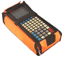 MC5
Data Collector
MC5
Data Collector
with CMT
Field v3.8
- Waterproof
(submersible)
- Operating temperature: -40°C to 54°C
- 1 MB RAM standard (2, 4, 8 MB optional)
- 8 line x 21 character backlit display
- Interfaces to laser rangefingers, barcode readers and various NMEA devices
- Two 9-pin RS-232 serial ports, PC/AT pinout
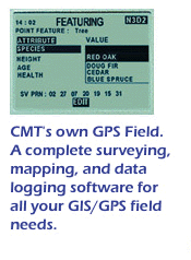 CMT
Field Software v3.8
CMT
Field Software v3.8
(RT-MC-Mapper Package Only)
- Collect Points, Lines Areas
- Feature/Attribute/Value GIS structure
- Graphic plotting.
- Traversing keyboard data entry to allow you to continue mapping
when GPS is obstructed
- Offset function to map hard-to-reach locations.
- Nested point function for tagging points while you are mapping a Line
or Area Feature.
- Averaging function to optimize accuracy while recording static points.
- LLA/UTM/SPC plus user-defined coordinates.
- Supports 50 datums plus user-defined datums.
- Provides area calculation in the field
- Interfaces to laser rangefinders, barcode readers and various
NMEA devices
- Canyon, Blockage and Clear modes for optimal tracking performance

The RT-MC Mapper 3.8 Package includes CMT's PC-GPS 3.8 software for comprehensive GPS project management and mapping. PC-GPS 3.7 provides functions for Mapping, Mission Planning, Batch Differential Correction, Static Point "Spread" analysis and Job Editing. The software also supports GIS layering, raster images (i.e. DOQs, DRGs, aerial photographs, satellite imagery), multimedia objects (OLE 2.0) and Microsoft® ODBC.

The RT-PC Mapper 5.5 Package includes CMT's PC-Mapper 5.5 software for comprehensive GPS project management and mapping. PC-Mapper 5.5 provides functions for Mapping, Mission Planning, Batch Differential Correction, Static Point "Spread" analysis, Job Editing and Integrated Field GPS/GIS software. The software also supports GIS layering, raster images (i.e. DOQs, DRGs, aerial photographs, satellite imagery), multimedia objects (OLE 2.0) and Microsoft® ODBC.
System Accuracy Specifications
| Real-Time Differential (DGPS): | |
|---|---|
| DGPS (RMS) | 2 m |
| DGPS (typical) | 1 - 3 m |
| Receiver Physical | ||
| Operating temperature: | -25°C to 55°C | |
| Battery Consumption: | 2100 mAH Battery
- Up to 7 hours of operation 4500 mAH Battery - Up to 15 hours of operation |
|
| Humidity: | 95% non-condensing | |