| |
|
CMT
is the leader in GPS/GIS
training by combining GPS theory with practical GPS/GIS data collection
and map building exercises.
|
|
|
CMT
Personalized Training
|
 Small
2 to 4 people class size Small
2 to 4 people class size- Personalized to your
needs
- Hands-on
for easier learning
|
|
- GPS and GIS
concepts covered
- Pre and post
data processing
- Register
here
|
|
|
|
Training Seminar
for GPS/GIS Training (Two Day Course): |
|
$395.00
|
Level
I training includes multiple field sessions to sharpen data collection
skills.
CMT Seminars teach techniques that can
be applied in a wide variety of applications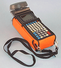
Natural Resources
- Forest Management / Cruising
- Habitat Inventory / Assessment
- Water Quality Assessment
- Fugitive Emissions Tracking
- Species Tracking / Inventory
- Natural Disaster Assessment
Utilities & Municipalities
- Pole / Substation Inventory / Inspection
- Meter Location / Inspection
- Pavement Inspection / Repair Assessment
- Sign Inventory / Inspection
|
|
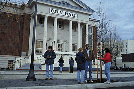
CMT seminars area mix of lecture, PC work and
multiple field sessions where the class goes outside and maps local features.
The key benefit of our seminars is that they are "hands-on".
Everyone gets to touch and use the equipment.
Participants are provided with a GPS unit
and taught how to properly collect data in the field. Then you will
go inside to make your own maps with our GPS/GIS Mapping software, exactly
as you will do in your own work.
This course is for people
who use GPS/GIS for general mapping applications such as:
- Forestry
- Agriculture
- Natural Resources
- Utilities
Students gain a thorough
understanding of GPS/GIS job management
from start to finish in a "hands-on" environment. Basic GPS and
GIS concepts are introduced. Intensive hands-on Field and
office exercises teach the skills necessary to perform actual GPS/GIS
mapping in real applications.
The student will learn essential GPS/GIS skills such as:
|
|
Field
|
Office
|
|
|
|
-
Mission Planning
- Job Design
- Feature List Creation
- Static/Dynamic Techniques
for collecting Points, Lines and Areas |
-
PC file transfer
-
Base station differential correction
- Data Quality Control
- Coordinate System Transformation
- GIS mapping/exporting
- Plot Output
|
Check Schedule
Register
|