Airborne Inspection is an all-in-one
complete package for aerial surveys
Software includes: PC-Mapper with Air-borne Inspection, GPS, GIS, Survey, Contour/Volume & Coordinate Geometry functionality.4
Automated Flight Preparation 4
Moving/Rotating Index Maps 4
Digitizing Feature List
4
Voice-mode Digitization
4
Flight Track logging in the background
4
GIS 4
Navigation/Stakeout |
|
|
|
|
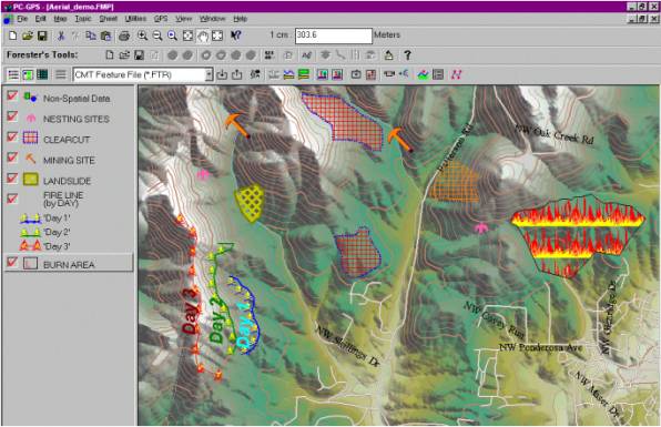
Airborne Inspection is an all-in-one complete package for aerial surveys. This
software combines the power of Scrolling and
Rotating Maps, GPS, Heads-up Digitizing (HUD), COGO functions,
full Mapping capabilities into one software utility. The Airborne Inventory at the
Forest Conservation Authority (a division of Quebec's Ministry of Natural
Resources) is used to evaluate/assess damages of all kinds (insects, disease,
fire...) caused to the forest of the Province of Quebec. CMT was chosen as
the developer to add airborne inspection functions to the PC-Mapper software
to automate and speed up the process of data collection and digitizing in an airplane. With a PC Tablet or a Notebook
Computer you can run Airborne Inspection in the air and bring a load
of data with you. For example, Airborne Inspection software allows you to
load multiple aerial photographs or DRG topo maps in the background for
assistance in navigation and feature mapping. During the flight data
preparation, “flight lines” are created by the Airborne Inspection software
to help delineate project areas and break up mapping sessions into grids for
easy navigation.
Plug in your GPS to show your position
and orient the moving/rotating map. Automatic scrolling and zooming help keep
you centered while you are doing the
digitizing inspection and collecting data directly into the PC. View real-time line length, offset
and acreage data on the spot. |
||
Rotating Map |
||
|
|
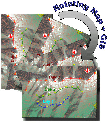
Set your map to automatically
"scroll" or "zoom" as you approach boundaries and
Airborne Inspection does the rest to keep you centered and correctly
oriented. Let the rotating map function keep you oriented. The software allows rotation
of the map to keep you heading "up" on the map (instead of always
looking at a "north-oriented" map). This feature assists in navigation by telling you
if you need to fly to the "right" or "left" instead of
"east" or "west". The example to the left shows a fire line map with the
progression of the fire line over three days. Using a heat sensor, the mapping
technician can digitize "hot spots and fire
lines" on-the-fly using thermal imaging. The hot spot map is then
immediately sent to the field chief and field crews on the ground for
necessary action. |
|
|
|
||
|
|
||
|
|
||
|
Click here for a printable brochure. |
|
|
|
Pricing per copy/license: Airborne Inspection 4.0 with PC-Mapper
= USD $2,500 + S&H
(Omit S&H for software download option.)
|
|
|