|
The
Forester's Choice for
GPS Surveying Under a Canopy
The choice for foresters.
Works well under tree canopy. Includes the industry's only built-in TRAVERSE function to let you collect
positional data even when GPS signals are not available, such as in extremely
dense canopy situations or in caves.
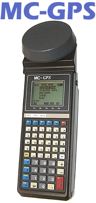
The rugged MC-GPS has
been in the market for over six years. Thousands of units are utilized in
rough forest terrain.
A proven and reliable
GPS unit for GIS applications.
MC-GPS is the
solution of choice for some of the most demanding GPS professionals in the
business, including:
- U.S. Forest Service
- The Nature Conservancy
- The Timber Company
- Bureau of Land Management
- U.S. National Park Service
- Bureau of Indian Affairs
- Weyerhaeuser
- Georgia Pacific
- International Paper
Let CMT's MC-GPS provide
you with the same reliability and ruggedness that the pros have come to
depend on.
|
|
|
|
|
|
System
Features
- 6-channel L1
frequency
- Full wavelength carrier phase on L1
- Carrier-phase smoothing
- Up to 1 Hz position update rate
- Up to 1 Hz code & phase measurements
- 1 PPS timing signal
- Superior performance under tree canopy
NMEA / Barcode Device Interface Capabilities
- Two 9-pin
RS-232 serial ports, PC/AT pinout.
- The MC-GPS has two waterproof DB-9 RS-232 serial ports (COM1: and COM2:)
for communication with your PC as well as a variety of additional input and
output devices such as:
RTCM-104 Version
2.0: Real-time DGPS
Simply plug your RTCM-104 source (i.e.FM pager, VHF radio, WADGPS) into the
MC-GPS's COM1: port. The MC-GPS will automatically detect and use the RTCM
message. Since the MC-GPS has two DB-9 serial ports, you can use COM1: for
RTCM and still have COM2: available for a barcode reader or NMEA output to
another instrument. Don't worry if you lose the RTCM message while you are
collecting data; the MC-GPS can be set to collect raw data and will
automatically warn you so you can post-process your data.
Compatible with
Coast Guard Beacon Receiver
Obtain real-time
differential correction with CMT's Coast Guard Beacon
Receiver package.
NMEA 0183
output
The MC-GPS will
send out a NMEA 0183 message, at an interval specified by you, to either
COM1: or COM2:. This functionality allows the MC-GPS to output a GPS position
to devices (i.e. digital cameras, sonar, etc.) that will accept a NMEA 0183
message. There is no need to change your instrument settings. The MC-GPS
communications can be set to match your instrument. In the NMEA Setup screen,
you have complete control over the baud rate and protocol settings.
Efficient Data
Entry with Bar Code Input
Attach a bar code
scanner to the MC-GPS and you can quickly enter data. Bar code menus can be
set up in such a way that you never need to touch the MC-GPS keyboard.
 Data Collector Features
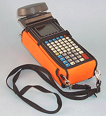
- Waterproof
(submersible)
- Audible beeper
- Operating temperature: -40°C to 54°C
- 8 line x 21 character backlit display
- 3 MB RAM standard (5 MB, 8 MB optional)
- Fully integrated GPS receiver, antenna and data collector in one
hand-held unit
- 55-key alphanumeric keyboard including 5 function keys and separate numeric
keypad
- Optional external antenna
- Rechargeable battery
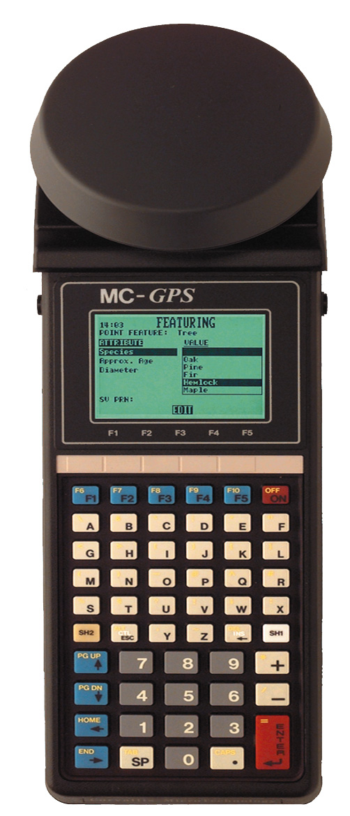
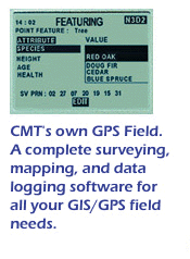 CMT Field Software
v3.8
CMT Field Software
v3.8
- Collect Points, Lines
Areas
- Feature/Attribute/Value GIS structure
- Graphic plotting.
- Traversing - keyboard data entry to allow you to continue mapping
when GPS is obstructed
- Offset function to map hard-to-reach locations.
- Nested point function for tagging points while you are mapping a Line or
Area Feature.
- Averaging function to optimize accuracy while recording static points.
- LLA/UTM/SPC plus user-defined coordinates.
- Supports 50 datums plus user-defined datums.
- Provides area calculation in the field
- Interfaces to laser rangefinders, barcode readers and various NMEA
devices
- Canyon, Blockage and Clear modes for optimal tracking performance
Obtain 2 cm + 2
ppm accuracy with Carrier Phase
Using the carrier
phase option, the MC-GPS-CM can attain centimeter-level accuracy (2cm+2ppm)
without separate data collectors, antennas or poles. Uploading and processing
your carrier phase data in PC-GPS is virtually
the same as processing C/A code data. Behind the scenes, however, is a robust
carrier phase processor (CMTCM) that will provide either a FIXED solution
(ambiguities fixed to integers) or FLOAT solution (ambiguities resolved to real
values). The program will notify you of which type of solution was used. You
may also process the same data with the standard C/A code processor by simply
selecting the CMT Differential processor.
The MC-GPS-CM offers the
ultimate in flexibility, allowing you to do a variety of tasks. It can be
used to record 1-3 meter data in addition to 2cm+2ppm data. For example, if
you have a job that requires 2cm+2ppm accuracy on the property corners but
only requires 1-3 meter accuracy on the streams running through the property,
the MC-GPS would be the perfect tool. It can perform both tasks in the field
without skipping a beat. In the past, you would have needed two different
types of GPS receivers to do this job.

The MC-GPS package
includes CMT's PC-GPS
software for comprehensive GPS project management and mapping. PC-GPS provides
functions for Mapping, Mission Planning, Batch Differential Correction,
Static Point "Spread" analysis and Job Editing. The software also
supports GIS layering, raster images (i.e. DOQs, DRGs, aerial photographs,
satellite imagery), multimedia objects (OLE 2.0) and Microsoft®
ODBC.
System
Accuracy Specifications
|
Real-Time
Differential (DGPS): |
|
DGPS
(RMS) |
2.5 m |
|
DGPS
(typical) |
1 - 3 m |
|
|
|
|
L1
Carrier Phase Post-Processing: |
|
Static
(RMS) |
2.5 cm
+ 1ppm |
|
Static
Spread (typical) |
2 cm +
2ppm |
|
|
|
|
L1
C/A Code Post-Processing: |
|
Static
(RMS) |
2.5 m |
|
Static
(typical) |
0.9 m -
1.5 m |
|
Time to
first fix |
60 sec.
typical, 40 sec. with
current ephemeris |
|
Drop
lock sensitivity |
-143
dBm costas threshold |
|
Acquisition
sensitivity |
-134
dBm costas threshold |
|
Reacquisition |
< 1
sec with < 10 sec interruption |
|
Velocity
(RMS) |
.05
m/sec. |
|
Maximum
velocity |
460
m/sec. |
|
Maximum
altitude |
18,000
m |
|
Maximum
acceleration |
2.5G |
|
MC-GPS Specifications |
|
Y2k: |
Year
2000 Compliant |
|
Operating
System: |
CMT
ROSII |
|
CPU: |
CMOS
8088, no memory wait states, operating at 10 MHz |
|
System
Memory: |
512Kb
RAM |
|
RAM
Disk: |
3 MB
internal standard. Optional 5 and 8 MB available. |
|
Environmental: |
Waterproof,
dustproof, shock-resistant |
|
Operating
Temp.: |
-40°C
to 54°C |
|
Display: |
8 lines
x 21 characters (8192 pixel graphics) |
|
Communications: |
Two
9-pin RS-232 serial ports (PC-AT Pin-out)
Baud rate configurable from 300-38400 bps |
|
Keyboard: |
55-key,
alphanumeric, tactile keyboard
with large numeric pad and 10 function keys (5 shifted). |
|
Size: |
12.35"
x 4.06" x 2.3" |
|
Weight: |
3 lbs
(48 ounces) including batteries and attached antenna. |
|
Velocity: |
Without
DGPS: 0.1 m/s With DGPS: 0.05 m/s |
|
Time: |
Without
SA: 1 pps +/- 50 ns RMS |
|
Position
Update Rate: |
Once
per second |
|
Maximum
Velocity: |
460
m/sec. (1000 knots/sec.) |
|
Maximum
Altitude: |
18000 m
(60000 ft) |
|
Maximum
Acceleration: |
2.5g |
|
|
|
GPS Receiver and Antenna Specifications |
|
Antenna: |
Integrated
Patch Antenna. Optional external antenna mounted on a rangepole or magnetic
disk available |
|
Channels:
|
6;
capable of tracking up to 6 satellites at once |
|
Frequency:
|
L1
(single) |
|
Signal
types: |
CA code
(SPS) standard; optional carrier phase, code tracking |
|
Sensitivity:
|
Drop
Lock of -143 dBm Costas threshold, Acquisition of -134 dBm |
|
Estimated Battery Life |
|
|
GPS
on |
|
GPS
off |
|
Shelf
Life |
Required
Recharger |
|
1600
mAH |
1 Day |
|
1 Week |
|
2
Months |
ACC-RE3B |
|
2100
mAH |
1 Day |
|
1 Week |
|
2
Months |
ACC-SMC-G3-M |
|
Performance |
|
|
Position: Mode |
Accuracy
in meters |
|
HDOP<4 |
|
|
|
CEP (50%) |
RMS (63%) |
2DRMS (95%) |
|
|
SPS with SA |
40 |
50 |
100 |
|
|
SPS without SA |
15 |
19 |
38 |
|
|
PPS |
11 |
14 |
28 |
|
|
Code Diff. |
1 to 2 |
1 to 2.5 |
1 to 5 |
|
|
Carrier Phase Diff. |
0.02 |
0.025 |
0.05 |
|
|
|