PC-GPS
version
3.8:
What else?
- Batch
import for PC-GPS feature files (*.FTR) and DXF files. Option to import
them into one or individual documents.
-
Dynamic display of distance and azimuth in the Measure Distance and Map – Add Feature functions.

- Ability
to convert any three consecutive nodes into an arc.
- Create
Mesh function now supports rectangular grids (defined by user).
- A pre-defined pattern/symbol table for displaying feature data. This is particularly useful when bringing field data into PC-GPS. The pattern/symbol table can be edited in the Custom Configuration dialog.
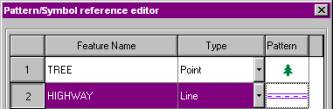
New features added to an existing
topic will automatically use the existing topic symbol.
- Width
can be changed for dashed lines.
![]()
![]()
![]()
- The
Sheet View will automatically update the built-in attributes if changes
are made.
- All
fields of the sheet view table are now maximized to fit the window size.
- Popup
Menu for Sheet View. You can change the color settings and also save the
Sheet View data to a .CSV file.
- Feature ID
or Sequence Number can be displayed in sheet view.
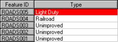
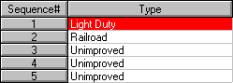
or
- Two new
built-in attributes have been added to the sheet setup: N_2DRMS_sec and E_2DRMS_sec.
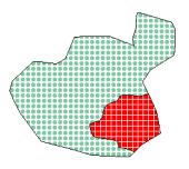
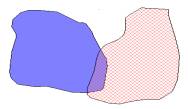
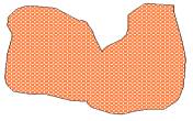
- The Join function has been enhanced to allow 2 overlapping areas to be joined into
1 area.
![]()
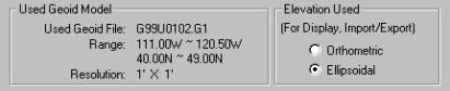
- Enhanced
Coordinate Information Screen shows you which Geoid Model is being used to
calculate orthometric height (MSL). In this screen, you may specify whether to
use HAE or MSL when displaying, importing or exporting elevations.
![]()
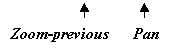
- Map
View enhanced with Pan and Zoom to Previous tools.
- Unitless
scale added to Map View and Plot Preview.
![]()
![]()
![]()
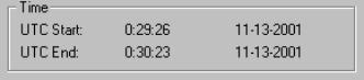
- File
Summary also displays UTC start and end times.
-
A USGS Quad reference has been added to the Load/Register photo dialog box.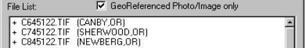
- When digitizing a feature, you may snap to another feature
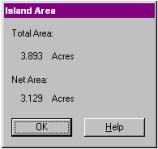
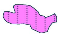
- Islands may share a border with the surrounding area.
Back to top of Page